Menu
Parish council logo
Bilbrook Parish Council
  • About the Parish
    • Bilbrook Walks
    • Clubs and organisations
    • Education services
    • Health services
    • History of the Parish
    • Leisure services
    • Local services
    • The Monarchs Way in Bilbrook
    • Visiting the parish
  • News
  • Events
  • Your Parish Council
    • Parish Councillors
    • Council Finances
    • Policies and procedures
    • Planning
    • Who does what?
    • Facilities & Services
    • Vacancies
  • Meetings
    • Upcoming meetings
    • Meetings 2021
    • Meetings 2020
    • Meetings 2019 and older
  • Contact Us
Close Menu

Jubilee Walk 2 Map

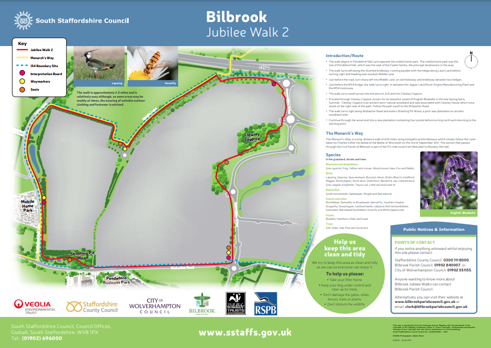
Bilbrook Jubilee Walk 2 – Wobaston Road, Lawn Lane, Bridleway Bilbrook 7, through Clewley Coppice and Past Jaguar Land Rover.  You may be surprised to learn that Jaguar Land Rover is in the Bilbrook Civil Parish and not Wolverhampton.  Click here for a map of Bilbrook Jubilee Walk 2

Please note: There is no vehicular access to the i54 Site from the Wobaston Road.

Update: 30.08.2019 – Due to work taking place on the i54 Western Extension the route is being diverted from Middle Road further north. The Parish Council is awaiting an updated map from the developers.

Update: 14.05.20 – The footpath is currently closed near the M54 (top of the map) due to the i54 Western Extension works. It is expected to be re-opened mid-2021.

Update: 30.11.20

– please follow the link below

Closure of Bridleway No 7 Bilbrook from 3rd December for 21 days

Route
Begins at the junction of Pendeford Hall Lane with Middle Lane
Behind this is the site of Pendeford Hall, now a caravan park, which was once the seat of the Fowler family, the principal landowners in the area.
Proceeds along Middle Lane almost immediately crosses the course of a Roman road
Route follows Middle Lane and veers left with this
Walk is towards the M54
As this is approached the i54 industrial park is seen on the right
The perimeter of i54 is skirted as the route swings southwards
To the right is Clewley Coppice, a semi-natural woodland
This was associated with Clewley House, which once stood on the right of the walk
Wobaston Road is gained and the route swings right, skirting playing fields on both sides of the road
Further down on the right is a former Shooting Pit
A little past this the walk turns right along Pendeford Hall Lane, broadly following the course of the Roman road referred to above


1. Jubilee Walk 1 3. Twentyman Playing Fields

Related Posts

Walks

Walks

Walks

  About the website

This is the official website for Bilbrook Parish Council. This parish is served by South Staffordshire District Council and Staffordshire County Council.

  Address

Bilbrook Village Hall
Joeys Lane,
Bilbrook,
South Staffordshire,
WV8 1JL

  Contact details

Phone: 01902 840007
Email : clerk@bilbrookparishcouncil.gov.uk

  Links

Privacy notice
Accessibility
South Staffordshire District Council
Staffordshire County Council
Login
Hospitals
Doctors
Chemists/Pharmacies
Education
Community
Libraries
Recycling centres
Rights of way
Transport links
This website uses necessary cookies to improve your experience. Cookie policyCookie settingsAccept
Cookies Policy

Privacy Overview


This website uses cookies to improve your experience while you navigate through the website. Out of these cookies, the cookies that are categorized as necessary are stored on your browser as they are essential for the working of basic functionalities of the website.
Necessary
Always Enabled

Necessary cookies are absolutely essential for the website to function properly. This category only includes cookies that ensures basic functionalities and security features of the website. These cookies do not store any personal information.

SAVE & ACCEPT